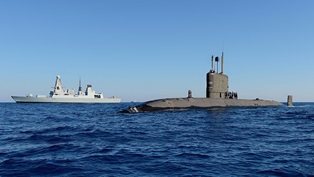
A Royal Navy survey ship has carried out extensive analysis of the River Tyne to help keep shipping flowing freely as she continues an epic deployment around the UK.
Diminutive inshore survey vessel HMS Magpie – named after the only warship to be commanded by the late Duke of Edinburgh – is now in Scotland after completing three months of survey work around the Port of Tyne, ensuring seafaring charts used by mariners are accurate.
Using her array of sensors and sonars, the 18-metre long, 37-tonne vessel scanned the ever-changing seabed, which morphs and shifts as large quantities of sediment moves with the tides, shifting the underwater landscape and changing previously safe approaches to ports.
Magpie is on hand to analyse the seabed, gaining an understanding of objects and hazards, to ensure naval and commercial shipping is able to flow freely in and out of ports crucial to UK security and prosperity.
“The River Tyne is a large, busy and complex body of water with depths subject to regular change due to silting and tidal action,” said Magpie’s Commanding Officer, Lieutenant Commander Hywel Morgan.
“Magpie’s work is key to maintaining a sound understanding of these waters and ensuring safe access to the upper reaches of the river by naval ships.
“We leave the River Tyne with a renewed understanding of its maritime environment and continue on the next leg of our 2022 deployment.”
Magpie’s small crew of nine built strong bonds with the Royal Navy Reservists based locally at HMS Calliope in Gateshead and, in exchanged for a berth and office space, were able to offer training and sea time to Calliope’s sailors along the Tyne.
University staff and students connect to the University Royal Navy Unit Northumbria also benefitted from sailing time with Magpie.
The Devonport-based ship – which will return home in late October after eight months of operations – has spent the last month in Aberdeen carrying out similar work, including surveying the new South Harbour, the largest marine infrastructure project underway in the UK and a big development for trade around the North Sea.
Magpie operates an EM2040 multi-beam Echo Sounder, which transmits a fan-shaped ping of high-frequency sound waves which then sends back underwater imaging.
“This data is gathered at such a high density that along with depth we are also able to visualise any object on the seabed,” said Lt Cdr Morgan.
The ship also operate a towed Sidescan Sonar which helps in mapping wrecks and other objects in deeper waters.
“We also collect a range of other geospatial data, including the nature of the seabed and water temperature, salinity and turbidity to better our understanding of these environments,” added Lt Cdr Morgan.
The ship has now headed further north to the stunning Caledonian Canal, including sailing Loch Ness.